Could December kick off on a wintry note?
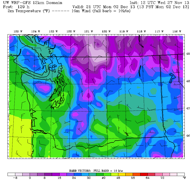
A blast of chilly arctic air is expected to plunge southward from Canada late this weekend, reaching the doorstep of Western Washington sometime on Monday. As the cold air trickles into the region, a Puget Sound Convergence Zone could form anywhere from Seattle (less likely) to Skagit County (more likely), potentially unleashing the first flakes of the season for some—and heartbreak for others.
That is, if you’re craving snow. If the white stuff isn’t your thing, Monday could very well be a joyous occasion.
But first, how about a calm, quiet Thanksgiving for all?
A mix of sun and clouds is on tap the rest of today through Thursday, with pleasant temperatures region-wide—highs will max out in the low 50s this afternoon and tomorrow. Some spotty showers are possible north of Seattle on Thanksgiving Day, but the city itself should remain dry—extending our streak without measurable rainfall to nine days. (Although very impressive for this time of year, that’s not quite a record—November 2000 logged 13 consecutive days without rain mid-month.)
Moisture finally returns to the region later on Friday, with on-and-off showers targeting the city through the evening and overnight into Saturday. Highs both days will stay near 50 degrees as high pressure moves away.

On Sunday, a much wetter system barrels in from the northwest, giving a soaking rain to the I-5 corridor for the first time in almost two weeks. Amounts will range from a third of an inch around Seattle, where the Olympic Mountains will eat up some of the incoming moisture, to 1 inch near Bellingham and Mt. Vernon. With the arctic air still hung up in B.C., temperatures will rise to the upper 40s.
It’s Monday when the winds of change really start to blow. A bulging dome of high pressure is forecast to settle in over Canada, driving much colder air south into Washington as the day progresses. Because arctic air is usually very dry, this is not a great recipe for much snow—typically in Seattle, our biggest snowstorms come when warmer, wetter air overrides cold air already in place. However, the big exception to this is the Puget Sound Convergence Zone, which can form along the boundary of an arctic air mass and dump several inches of snow in a short period of time. (An extreme example of this occurred on Dec. 18, 1990, when downtown Seattle was buried in a foot of snow.)
As of noon today, forecast models have waffled back and forth on the location of a possible Convergence Zone, placing it anywhere from North Seattle to northern Skagit County. To further complicate matters, the most recent models runs are holding the cold air back longer—and shunting more of it east of the Cascades.
Still, a Convergence Zone is a decent possibility sometime on Monday—and, should there be enough cold air lurking nearby, a couple inches of snow could easily fall. The highest odds for this will be further north in Snohomish and Skagit counties, with lower chances in the Seattle-Tacoma area thanks to shadowing from the Olympics.
Regardless of any snow, though, chilly temperatures are still on the way, with highs struggling to reach 40 degrees Monday through Wednesday as cold air infiltrates the region. (If earlier forecast models are correct, it’ll be more like the mid 30s during this time frame.)
Bottom line: it’s going to feel a whole lot more wintry come December. It just might not be all that white.


