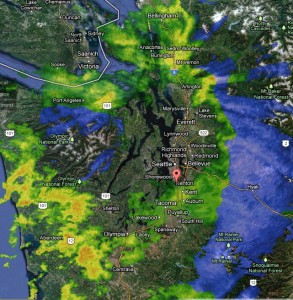
Forget the umbrella. The Olympic rain shadow has us covered.
Upper-level winds over Western Washington are blowing straight from the west today, placing the Olympic Mountains directly in the path of rainfall intended for the Seattle-to-Everett corridor. When that happens, precipitation that would otherwise reach the metro area is wrung out along the western slopes of the Olympics—effectively blocking a large swath of King and Snohomish counties from receiving much, if any, rainfall. (During the fall and winter, the upper-level winds are usually from the southwest, ensuring Seattle stays wet.)
To wit, only .02 inches of rain has fallen at the UW campus north of downtown Seattle as of 1 p.m., with no rain whatsoever reported further north at Paine Field in Everett. Even south of downtown, on the edge of the rain shadow, amounts have been fairly light so far—.07 inches at Boeing Field and .06 at Sea-Tac.

Outside of the rain shadow, however, steadier rains have fallen, with .28 inches to the south in Olympia, and .30 inches up in Bellingham. Moderate showers will continue in these areas for a few more hours, while places from downtown Seattle to Everett, sheltered by the Olympics, skate by dry.
We lose our umbrella tomorrow morning as the upper-level winds shift to the northwest, bringing more rain back into Seattle. Amounts should total around a quarter-inch for most—nothing too significant, but more than the dribs and drabs of today. Temperatures will also run a notch below average, peaking near 45 degrees.
The rain lingers into Saturday morning, especially north of Seattle in a Puget Sound Convergence Zone. By Saturday afternoon, showers should be done everywhere as partly cloudy skies take hold. With clearer skies, temperatures overnight will dip into the mid 30s in Seattle—and toward the freezing mark outside the city.
Rain is possible again on Sunday, but with an upper level ridge building over the eastern Pacific, the heaviest of the moisture should get shoved into Canada—leaving us with more of a light drizzle. A dry day is then likely Monday, before a fresh round of rain arrives on Tuesday—rain that you’ll need your umbrella for.
Since the Olympic Mountains won’t have our back anymore.


