
The joking ends Tuesday.
Over the past 10 days, we’ve been teased with spits and spats of rain—a burst of precipitation here, a passing shower there—but nothing substantial and widespread has affected the region. That all changes in the next 48 hours, with the arrival of a powerful storm system bent on delivering some serious rainfall—to the tune of an inch or more.
Until then, showers of the lighthearted variety will continue moving through the area, picking up in intensity later tonight as a warm front approaches. Amounts should top out near a third of an inch.
Additional light rain carries over into Monday morning before fizzling out in the noon hour, leaving Seattle with overcast skies and temperatures in the upper 40s to lower 50s. Should we hit 50 degrees, it would make for just the second time in over a month that’s happened—with Friday’s high also reaching the 50-degree mark. Prior to that, the last 50-plus reading in the city was Dec. 4.
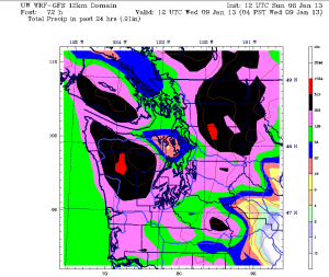
After a calm Monday night, the serious stuff begins in earnest early Tuesday as a vigorous cold front barrels ashore. Moderate rain should begin falling across the metro area by daybreak, becoming heavy during the afternoon hours. By Tuesday night, pounding rains and gusty winds are likely across all of Western Washington, with rainfall totals topping an inch from Seattle to Olympia. Further north, over Snohomish County and Whidbey Island, amounts will be slightly lower due to shadowing from the Olympics.
The storm winds down on Wednesday, but with plenty of leftover moisture hanging around, scattered showers are a good bet throughout the day. High temperatures will cool back into the lower 40s in the wake of the cold front, plunging into the mid 30s overnight.
Which brings us to Thursday. With colder air streaming in overhead and a few showers still roaming about, wet snow is possible later in the day for places roughly 300 feet or higher in elevation—especially along the North Seattle-to-Everett corridor. However, recent weather models have trended drier for the day—meaning that even though it’ll be cold enough for snow in several areas, we probably won’t have much moisture to work with. That said, any showers that crop up Thursday night should be in the form of snow—instead of rain.
And that’s no joke.


