

It took over a century for Seattle to record three 100-degree days.
The next three could be in the bag by Monday.
A towering ridge of high pressure is forecast to park directly over the Northwest this weekend, likely sending Seattle temperatures to levels seldom, if ever, reached in the 125-plus years that weather observations have been taken in the city.
The high temperatures currently predicted by a variety of weather models are, to put it bluntly, simply outrageous—stretching the limits of what our typically mild, marine-influenced climate is capable of churning out. Or so we thought. Below, we provide answers to the most commonly asked questions about the upcoming heat wave.
When will the heat wave start?
The heat wave will begin on Friday, with temperatures soaring to near 90 degrees—roughly 15 to 20 degrees above normal for late June. While borderline hot already, that won’t be enough to set a new daily record high—as June 25 happens to hold Sea-Tac Airport’s all-time June high temperature record of 96 degrees. The record high temperatures for Saturday, Sunday and Monday, however, will likely be shattered—and then some.
How hot will it get in Seattle?
Seattle is likely to skyrocket into the upper 90s on Saturday, perhaps touching 100 degrees, before probably climbing into the low 100s on both Sunday and Monday. That’s right, the low 100s. That’s not a typo.
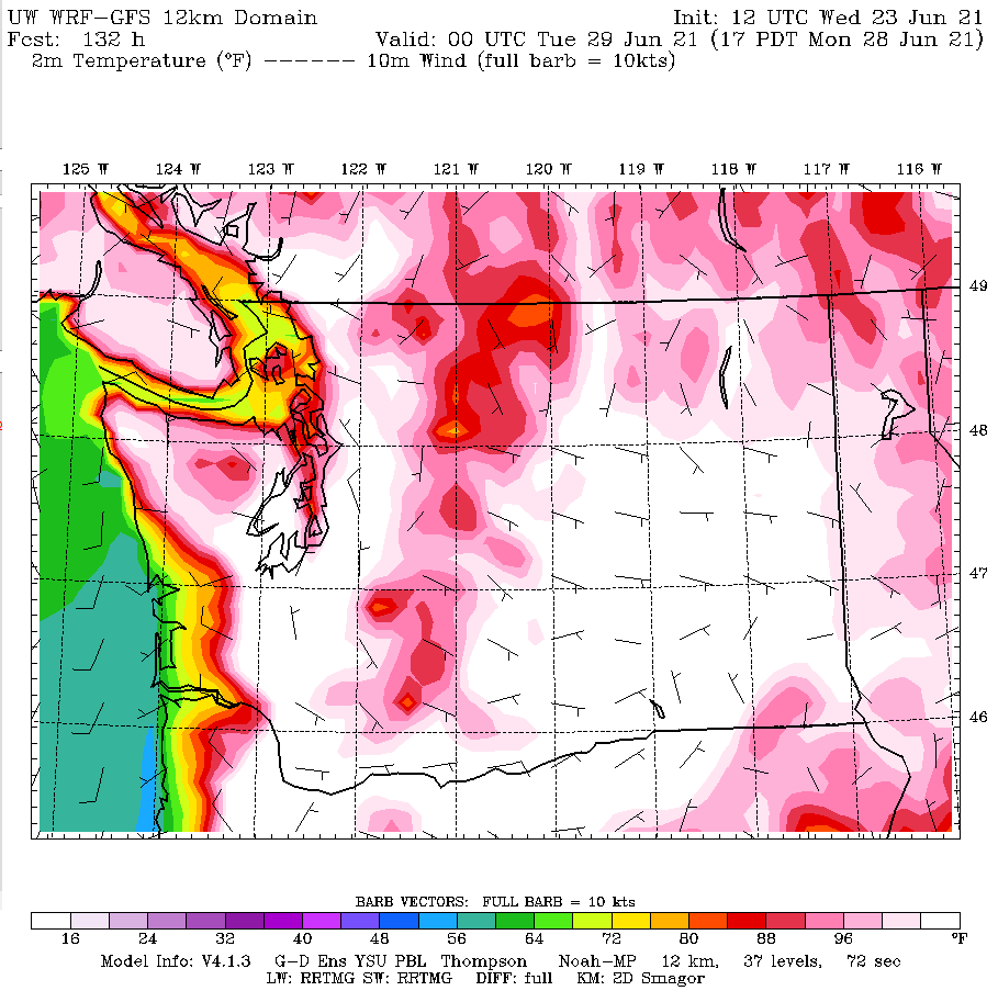
It’s important to note, however, that some areas of the city will be hotter than others—particularly places away from shorelines and south of downtown. Sea-Tac Airport, where the city’s official weather-reporting station is located, is likely to be among the hottest spots in the region. Alki Beach, on the other hand, may only be in the 80s.
Back-to-back 100-degree days in Seattle?!? Has this ever happened before?
Consecutive 100-degree temperatures have never been recorded in Seattle. The closest the city came was in August 1981, when the mercury topped out at 99 degrees on Aug. 9, and 98 degrees the day after.
What’s the hottest temperature ever recorded in Seattle?
Officially, the highest temperature ever recorded in Seattle is 103 degrees, set on July 29, 2009, at the height of a punishing four-day heat wave. That temperature was recorded at Sea-Tac, which has served as Seattle’s official weather-reporting site since 1945. However, on that same day, 105-degree temperatures were recorded at both Boeing Field in South Seattle and the National Weather Service office in North Seattle.
How many times has Seattle hit 100 degrees?
Officially, Seattle has reached 100 degrees on three occasions: July 29, 2009 (103), July 20, 1994 (100) and July 16, 1941 (100). The 2009 and 1994 observations were at Sea-Tac Airport. The 1941 observation was at the Federal Building in downtown Seattle, which served as the city’s official weather-reporting site from 1894 to 1945.
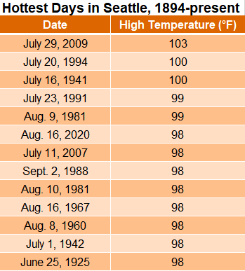
The National Weather Service notes that the old Federal Building site also reached 100 degrees on June 9, 1955—but at that point, the site no longer served as the city’s official climate-reporting station. Sea-Tac Airport reached 96 degrees that same day, setting the airport’s record high for June, later tied in 1995 and 2017. The official all-time June record for Seattle is 98 degrees, set on June 25, 1925, at the Federal Building—back when it was still the city’s official site for weather records.
Could the upcoming heat wave break the all-time record from 2009?
The short answer is yes. I believe there’s close to 50-50 odds that the temperature will reach 104 degrees or higher on Sunday or Monday, eclipsing the 103-degree record from July 29, 2009. The strength of the sweltering high pressure ridge, in combination with a hot wind blowing east to west across the Cascades both days, could do the trick.
Will it cool off during the nights?
Unfortunately, temperatures will stay rather warm at nighttime throughout the duration of the heat wave—potentially remaining above 70 degrees on both Saturday and Sunday night. The all-time record for warmest low temperature in Seattle (in other words, the hottest night ever) is 71 degrees, set on July 29, 2009.
When will the heat wave end?
On Tuesday … kind of. Unlike classic Northwest heat waves, which are often brought to an abrupt halt by a reversal in wind direction (where the wind shifts to blowing in from the cool waters of the Pacific Ocean), this one looks to linger around for a while, only gradually abating in intensity as we head farther into next week.
That’s because the ridge of high pressure responsible for the sweltering heat is predicted to only shift slightly east next week, effectively capping the amount of cool ocean air that can seep into the Seattle area from Tuesday onward. So, while Tuesday likely won’t be nearly as hot as Sunday or Monday, temperatures will probably still flirt with 90 degrees, before slowly dropping back in to the mid-80s midweek as more marine air trickles into the region. Unfortunately, even the long-range models don’t show much hope for a return to normal early summertime temperatures—i.e., highs in the mid 70s—anytime soon.


Glad I just put in our three window A/C units.
[…] day, it’d be extra bearable, however this scorching spell is relentless. Earlier than this yr, Seattle has seen just three days at or over 100 degrees since 1894. Now we’ve got had three 100-plus-degree days in a row. Because of this, many people are […]