

It wasn’t that long ago that Seattle was mired in a snowless rut, receiving just 0.8 inches of total snow from February 2014 to December 2016—a nearly three-year stretch of snow futility.
Boy, how the tables have turned.
After three straight winters of respectable—or remarkable, in the case of last winter—snowfall, Seattle appears in good position to pull off yet another winter with at least 4 inches of snow to its name. Notably, such a feat hasn’t been accomplished in the city since the 1970s, a decade which began with six straight 4-plus-inch winters.
But, as any Pacific Northwest weather guru knows, it’s wise to not count your chickens before they hatch. With that in mind, let’s dive in to the snow possibilities in the days ahead—starting with the most difficult one: Sunday.
Snow, round 1: A Snohomish County special?
An arctic front will plow across the international border Sunday morning, diving into America from the northeast as bitter cold air pours out of the Fraser River Valley. Powerful winds will let loose on Whatcom County and the San Juans, gusting up to 60 mph as the frigid air takes hold. Snow is also very likely in and around Bellingham, with several inches possible by early Sunday afternoon.
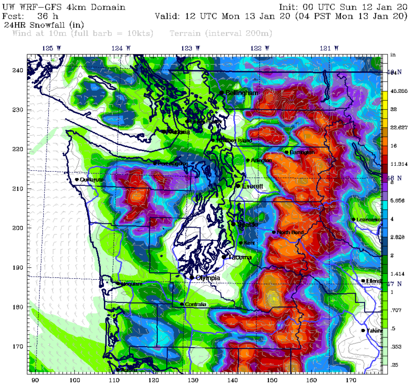
It’s what happens next that is anyone’s guess. As the arctic front races down the I-5 corridor—mind you, Mr. Mega-Mass of Cold Air, the speed limit drops from 70 to 60 mph by the Tulalip Casino—it’s likely to collide with warmer, moister air jetting up from the south. Wherever this zone of impact occurs is where the highest snowfall totals on Sunday are likely to be, as the Puget Sound Convergence Zone sets up shop.
Based on past instances, I’d say this spot is most likely to be over northern Snohomish County—specifically, near Stanwood and Camano Island. But, all of Snohomish County is fair game. The South Everett/Lynnwood/Mill Creek area also tends to be a favored spot.
How much snow are we talking for the metro area?
For those lucky enough (or unlucky enough, as I realize some of you do despise the white stuff) to find yourselves in the crosshairs of a snow-generating PSCZ, up to 6 inches of snow is possible, mainly between 3-9 p.m. Sunday. However, these amounts will be isolated and are likely to fall in a narrow band of 10 miles or so. Note that forecast models tend to struggle mightily with the Convergence Zone, and often underestimate totals in events like this. So, I do suspect that a few places in Snohomish County will hit the jackpot, with higher snowfall totals than modeled.
Importantly, most places in the metro area will likely see much lower amounts, ranging from a trace of snow to 2 inches. Slightly higher totals are possible on the edges of the Convergence Zone (i.e., northern King County). The hard-working folks at the National Weather Service have taken all of this into account, issuing a Winter Storm Watch for the metro area Sunday afternoon and evening, for a trace to 4 inches of snow.
What about Seattle?
Seattle proper is likely to be on the lower end of these totals, with some spots near the water (like Ballard and U-Village) struggling to record a meaningful dusting. On the other hand, higher-elevations spots in the city, like Queen Anne and Capitol Hill, could pick up a solid 2 inches. At Sea-Tac Airport, where Seattle’s official snowfall totals are measured, an inch of snow by midnight is a safe bet.
How cold is it going to get?
Perhaps the bigger story here, at least through Monday, is the cold temperatures. As the arctic front overtakes Western Washington, temperatures will rapidly fall, going from the mid-40s around lunchtime in Seattle to the upper 20s by Monday morning. This means that whatever snow falls on the roads Sunday night is likely to stick around—making for a potential messy Monday morning commute. School districts in King and Pierce County should prepare for delays Monday morning. Snohomish, Skagit and Whatcom County schools should prepare for possible closures.
In the wake of the arctic front, high temperatures will tumble to near freezing on Monday, before likely dipping below the freezing mark both Tuesday and Wednesday.
Shut-down-the-city snow possible Wednesday into Thursday
Beyond Tuesday, the forecast trends even more ominous, with the potential for a highly disruptive snowstorm across all of Puget Sound, including Seattle proper. Some models suggest that an area of low pressure will move inland near the mouth of the Columbia River—a near-perfect trajectory for significant lowland snow in Seattle, given the cold air in place.
Up to 6 inches of snow could fall in the city from Wednesday into Thursday—although I’d lean toward 2-4 inches at the moment. Highs will only warm a tad into the mid-30s—promising a mess of slush, ice and gridlock on area roads should this come to fruition.
Stay tuned as the situation evolves, and be sure to follow us on Twitter for real-time updates.


Thankfully it’s a Sunday (no weekday commute) and the Seahawks-Packers game is in Lambeau Instead of Century Link. Anyone remember a couple of nightmare commutes more than a decade ago, 1 also during a Packers game and 1 at this same time of year?
https://www.seattlepi.com/seattlenews/article/Nightmare-for-drivers-Snow-commute-and-a-1220896.php
https://www.seattlepi.com/seattlenews/article/Slick-roads-keep-police-tow-trucks-busy-1225137.php