

Maybe we should just it call the border storm?
A potential winter-weather maker is projected to sweep across the Puget Sound region right before November meets December—call it the November-December border—with wet snow accumulations possible north of the King-Snohomish County border on Wednesday. South of this line, including in Seattle proper, snowfall amounts look much more, well, borderline.
OK, on to the details, before the repetition of this word causes your mood to border on annoyance …
Cold air settles in Monday, snow chances rise by Tuesday night
In the wake of a chilly storm that will dive down from the north Sunday night, colder air will begin spilling into the northern reaches of Western Washington on Monday morning, leaking southward across the Canadian border (sorry!). This will set the stage for a rather nippy Monday across the Seattle metro, with high temperatures struggling to top 40 degrees. For context, the normal late-November high in the city is around 50 degrees.
Clearing skies late Monday into early Tuesday will likely allow temperatures to dip below the freezing mark—even in downtown Seattle—before another storm approaches from the northwest Tuesday afternoon.
It’s this storm in particular that bears close watching, as its precise path will have significant implications for snowfall across the region. If the storm passes by too far to the north—say, over Vancouver Island—warmer (relatively speaking) winds off the ocean will likely boost temperatures just enough to make for a cold rain below 500 feet in the Seattle area.
On the other hand, if the storm journeys further to the south—say, along the Washington coast—it will pull in colder, Canadian air from up north. As this bitter air heads southward, it would likely collide with moisture spinning up from the storm off the coast, unleashing a blanket of white over much of the I-5 corridor from Tacoma northward.
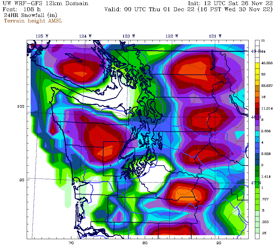
Such a snowy scenario is painted by Saturday morning’s University of Washington weather model, which projects over 4 inches of snow falling from Tuesday night into Wednesday morning in and around the Seattle area. Other weather models are less than enthused over the idea of a Seattle-area snow event, as they generally track the storm too far northward to bring the snow level down to the surface.
The prediction: Sticking snow unlikely in Seattle, with minor accumulations possible to the north
So, what’s the most plausible scenario right now? Will Seattleites wake up to the glories of a winter wonderland come Wednesday—or to the pain of a 35-degree rain?
At this point, the latter scenario appears most likely—although I do think that the rain is likely to mix with snow throughout the early morning hours on Wednesday, before transitioning to just plain old rain by midday. Much of the same will probably hold true for areas to the south of Seattle as well, with a rain/snow mix becoming all rain as the day progresses in Tacoma and other South Sound communities.
North of Seattle, however, the script could turn out a bit different. With slightly cooler temperatures in place north of the King-Snohomish line, wet snow is more likely from Lynnwood to Everett and points east from Tuesday night through Wednesday morning. However, even then, accumulations will probably be limited to rooftops, cartops and grass, rather than roadways. By later Wednesday afternoon, even these areas are likely to change over to steady rain as warmer air scoots in from the west.
If this not-as-snowy-as-you’d-like forecast has you singing the blues, take heart: All hope is not lost! A reinforcing shot of cold air is possible Thursday, with additional snow chances in Puget Sound country right on through next weekend.
In other words, winter may only be getting started. May your mood border on excitement.


[…] tits now. Here comes snow! Maybe. It’s looking unlikely, but there’s a slim chance we may get a couple of inches of snow on Tuesday, though it probably […]
[…] tits now. Here comes snow! Maybe. It’s looking unlikely, but there’s a slim chance we may get a couple of inches of snow on Tuesday, though it probably […]