

I-90 runs west to east across Seattle, but tonight it may also serve as a north-south dividing line of sorts.
Between the snow-haves and the snow-have-nots.
To the north of I-90? Snow, potentially several inches’ worth, is possible.
The south? Little to no snow is the most likely outcome. Let’s dive in to the details.
Winter storm warning issued as snow threat increases
A moisture-laden warm front is slated to trek across the Seattle metro around 8-10 p.m. tonight, before plowing northward into Canada by the midnight hour. With very cold air in place—temperatures in most spots have barely reached the freezing mark as of late this afternoon—the associated precipitation will fall as snow, not rain. In response, the National Weather Service in Seattle has placed all of King, Snohomish, Skagit and Whatcom counties under a winter storm warning, in effect until 7 am tomorrow.
The million-dollar question: Where exactly will the associated precipitation fall? More specifically, how far south into King County will the southern edge of the precipitation make it?
The most likely answer? About I-90, or the southern extent of downtown. The University of Washington’s latest high-resolution WRF model predicts that the precipitation—snowfall—will rapidly dwindle south of I-90, leaving southern parts of Seattle with very little snow—perhaps a dusting to a trace. Sea-Tac Airport, where Seattle’s official weather records are taken, stands a good chance of getting skunked. The airport already has missed out on most of the snow this week, logging just 0.2 inches since Sunday. By comparison, the National Weather Service office on Sand Point has recorded 3.1 inches.
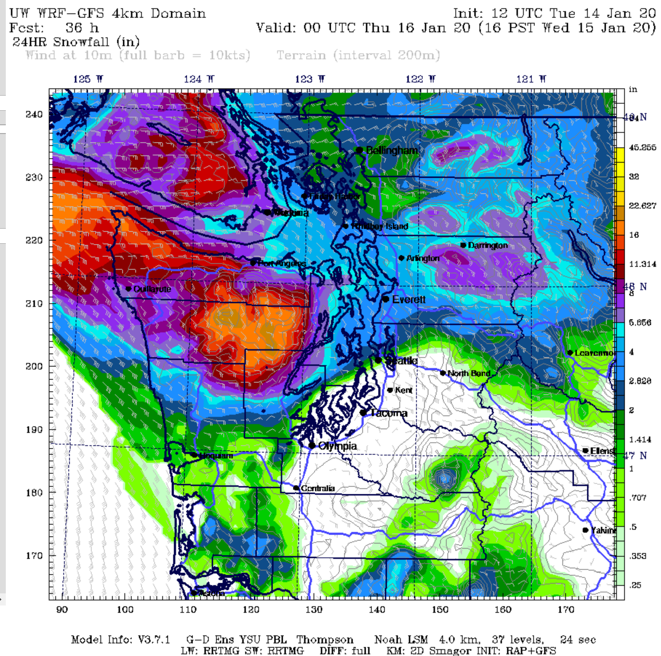
North of I-90, however, it’s likely to be a far different story—especially the farther north you go. The same UW model calls for rapidly increasing snowfall totals from downtown Seattle into the U-District, Northgate and Shoreline. 1 to 4 inches of snow is likely here. The same holds true for the Eastside: Renton and Newcastle are unlikely to see much in the way of the white stuff, while Bellevue, Kirkland, Redmond and Woodinville could see up to 4 inches.
More snow for Snowhomish…er, Snohomish…County
North of 205th Street—that is, the infamous King-Snohomish County line, otherwise known as the flagship office of the Puget Sound Convergence Zone—amounts are likely to be even higher. Places that have already seen 4 to 5 inches of snow since Sunday night—such as Lynnwood, Mill Creek, Bothell and Everett—look poised to pick up another 3 to 5 inches. Further north, from Marysville up through Mount Vernon and into Bellingham, another 1 to 3 inches of snow is also possible.
What about tomorrow?
If this forecast materializes, the morning commute tomorrow is likely to be very treacherous from Seattle northward, as drivers confront a plethora of snow, ice and all-around hazardous roads. The same school districts that have been shuttered Monday and Tuesday are likely to be closed again tomorrow too: Shoreline, Mercer Island, Bellevue, Lake Washington, Issaquah, Northshore, Everett, Edmonds and Mukilteo will probably all log their third snow day of the school year. Seattle Public Schools, coming off back-to-back 2-hour late starts, stands its highest chances this week of being closed.
Lighter snow, plus strong foothill winds, later tomorrow
But wait, there’s more! Another round of light snow is possible for all of Puget Sound by tomorrow afternoon, although the greatest impacts are likely to be concentrated further west, toward the Kitsap Peninsula. And last but not least, foothill communities could see easterly winds gusting to 60 mph as the next area of low pressure approaches offshore.
In short, what promises to be an extremely active 24 hours of weather is knocking on our doorstep. Follow us on Twitter for real-time updates as the situation continues to evolve.


[…] Snow and wind and ice for the new year in SeattleImage credit: Seattle Weather Blog […]