

Halloween is still over a week away, yet the first flakes of the season could fly as low as 1,000 feet this weekend. What’s more, the next several months are expected to be dominated by La Niña conditions, which often lead to chilly wintertime temperatures in Western Washington.
Does this mean that Seattle is in for an exceptionally snowy winter?
The short answer: Probably not—but a slightly snowier-than-average season appears likely.
To understand why, let’s start with some La Niña 101.
La Niña in Seattle: Cool and wet, but not necessarily with gobs of snow
La Niña episodes, which are characterized by below-average temperatures in the equatorial Pacific Ocean, typically lead to cooler, wetter winters in our neck of the woods. This is especially true in the December-to-February months, which is why it comes as no surprise that NOAA is predicting both soggy and chilly conditions during this timeframe.
But in Seattle, cool and wet doesn’t necessarily mean snowy—especially when you consider that the average daytime high during the winter is in the mid to upper 40s. A stretch of days with highs in the low 40s and overnight lows near freezing easily counts as cooler-than-normal by our wintertime standards.
That said, just about all La Niña winters in Seattle do feature snow at some point—in stark contrast to El Niño winters, which often yield little to no snow. In fact, an examination of Seattle-area snowfall over the past 40 years shows that La Niña winters average around 7 inches of snow, compared to the city’s annual norm of 5.9 inches.
An extra inch may not sound like a lot, but our annual snowfall average is somewhat skewed by big snowfall years, such as 2008-09 and 2018-19. I suspect that median snowfall in a La Niña year is actually 2 or 3 inches greater than normal. And make no mistake, an extra few inches of the white stuff is a big deal in a city often paralyzed by the sight of flurries.
Interestingly enough, this same analysis from the past 40 years suggests that neutral winters—that is, winters where neither El Niño or La Niña conditions are present—tend to be snowier than La Niña winters for Seattle. But that’s getting a bit into the weeds, so let’s stop there and cut straight to the chase with our key predictions for the coming winter.
Winter 2020-21: A warm start, then a cold finish?
A hallmark of many La Niñas in the Northwest is a warm November—and we think this coming November will follow suit. During La Niña years, a ridge of high pressure often sets up near the West Coast in November, leading to occasional balmy conditions in Puget Sound.
To wit, Seattle’s warmest November on record occurred four years ago during a La Niña episode, with an average temperature of 50.9 degrees. November 2016, which was punctuated by a record-breaking 70-degree reading on Election Day, was then followed by the city’s coldest December since 2009, and coldest January since 1985. Interestingly enough, Seattle’s third and fourth-warmest Novembers—1949 and 2008—also occurred during La Niña years, and were also followed by very cold (and very snowy winters).
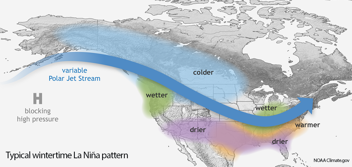
In many La Niña years, this ridge of high pressure—which blocks storms from moving in west-to-east fashion—tends to move further west over the Pacific Ocean as the calendar flips to December/January. As shown in the illustration from NOAA above, this forces storms to travel further north into Alaska to navigate around this so-called “blocking” ridge of high pressure.
Once these storms have completed their journey up and over the top of the ridge, they often barrel southeastward down the backside—toward the Pacific Northwest, picking up colder Canadian air and Pacific moisture along the way. And boom, therein lies the recipe for Seattle snow.
Ultimately, we anticipate this textbook La Niña pattern to prevail across the region during the core winter months of December, January and February, leading to largely cool, wet—and at times, snowy—conditions.
Snow forecast: 6-10” of snow, most likely during December-February timeframe
Based on all of the above, we’re calling for a slightly snowier-than-average winter, with a ballpark guess of 6 to 10 inches of total snowfall for Seattle, as measured at Sea-Tac Airport. We think the majority of this will fall after Thanksgiving—likely in December and January, and probably over the course of a few small to medium-sized snowfalls, versus one large storm.
The bottom line: If you’re hoping for a better performance in the snowfall department after last year’s 0.7-inch dud, the odds are in your favor. You can thank La Niña.


