
Batten down the hatches and put those flashlights on standby—high winds are likely in the Seattle area on Monday.
A powerful area of low pressure is forecast to barrel ashore near the southern tip of Vancouver Island just after midnight on Monday, then track eastward into the mainland of southern British Columbia in the pre-dawn hours. Current weather models have the low deepening to around 975 millibars before landfall—a pressure low enough to generate fairly strong winds across all of Western Washington
In addition, the expected track of the low is close to ideal for a decent Western Washington windstorm, as several of the region’s high wind events have come from lows following a similar path. This includes the devastating Hanukkah Eve Windstorm of December 2006 that also slammed into southern Vancouver Island—although, importantly, the low in that storm was a bit stronger, with a central pressure near 970 millibars before landfall.
Fortunately, because Monday’s low is weaker (and also because it’ll lose strength as it moves inland), peak winds won’t be on par with the destructive speeds seen back in ’06, which included a record-setting 69 mph wind gust at Sea-Tac Airport. This time around, maximum wind gusts should reach 55 mph—maybe 60 mph in a few windier spots—making for a more “middle-of-the-road” windstorm on Monday. With that said, the threshold for widespread power outages in the metro area is right around 55 mph—so a good number of people will likely lose power as tree branches come down. Because of this, the National Weather Service in Seattle has issued a High Wind Watch for the region, effective from Sunday night through Monday morning.
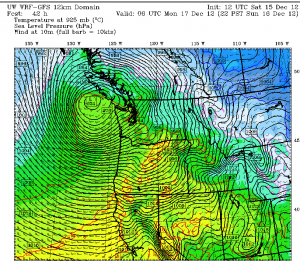
As for the timing of the storm, the main impact looks to be between midnight and 10 a.m. on Monday—with the highest gusts in Seattle between 4 and 8 a.m. This is because Puget Sound gets its strongest winds when the low is due north of the region (over Vancouver, B.C., in this case)—as the difference in pressure from south to north (higher in the south, much lower in the north) causes strong winds to race up the I-5 corridor. The location of the Olympics to the west and the Cascades to the east also helps, as air rushing north toward the low is squeezed between the two mountain ranges, further increasing wind speeds.
Once the low moves east of Vancouver late Monday morning, the wind will slowly die down, but breezy conditions are still likely through the afternoon. On-and-off rain showers will be a good bet as well—but the bulk of the rain associated the storm will fall late Sunday night.
Much colder air will also filter into Western Washington in the storm’s wake—dropping temperatures from the upper 40s on Monday morning into the mid 30s later that night. By Tuesday, scattered snow showers will be possible close to sea level—including in some parts of Seattle away from the water.
The colder air, courtesy of an upper level trough, will stick around until Wednesday afternoon, giving a chilly rain or a rain/snow mix to most areas. For Seattle proper, a sticking snow looks unlikely both days—but a quick inch or two isn’t out of the question from Shoreline to Everett, and in places east of Lake Washington. In any case, high temperatures through Wednesday will remain chilly—barely reaching 40 degrees.
In other words, while you’re searching for a flashlight for Monday’s storm, you better dig out the winter coat as well.


