
It rained yesterday like it never has in September before.
Seattle registered a staggering 1.71 inches of rain on Saturday, making it the wettest September day in the city since record-keeping began over 120 years ago. In doing so, Seattle toppled the previous one-day mark of 1.65 inches, set back in 1953 and tied in 1978, while simultaneously crushing the 65-year-old daily rainfall record for Sept. 28 of 0.83 inches.
In addition, yesterday’s deluge—which dropped more rain on Seattle in 24 hours than the city averages in an entire September—helped boost our monthly precipitation tally to a whopping 4.85 inches. This makes September 2013 the third-soggiest September on record in Seattle, trailing only 1978 (5.95 inches) and 1969 (5.57 inches).
Oh, and there’s another inch on the way.
After an early morning reprieve, rain is already spreading back in the Sound, ahead of another powerful storm system set to blast through the area tonight. As this system nears the coast later this afternoon, the rain should really pick up in intensity, with a soaking half-inch possible in the three hours between 5 and 8 p.m. More heavy rain will follow for the rest of the evening, with isolated thunderstorms also possible as the system—which has tapped into the remnants of a former typhoon near Japan—closes in on us.
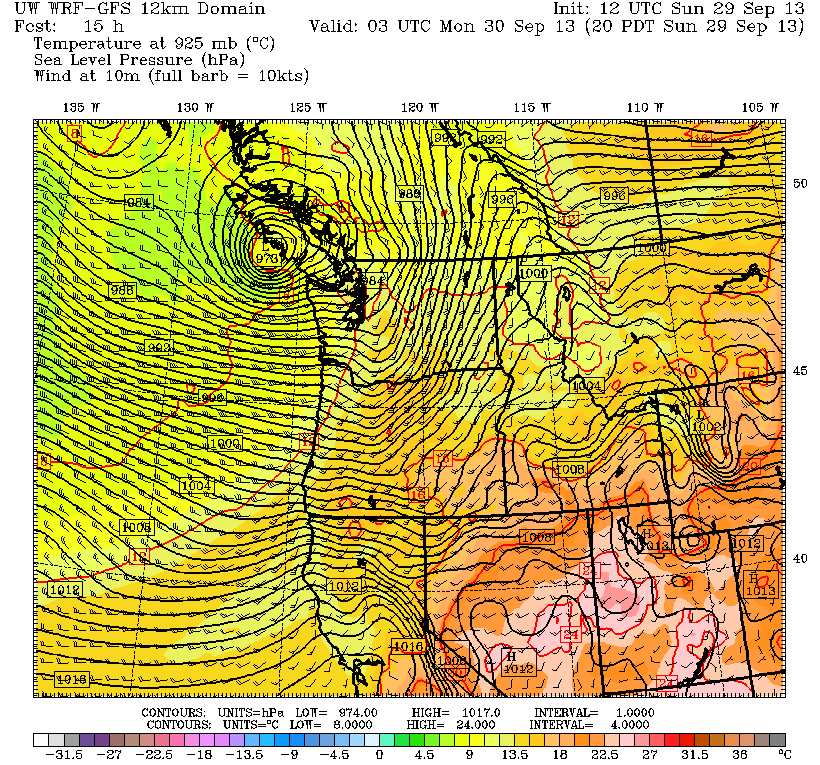
Outside of tonight’s downpours, there’s an even more serious threat for Western Washington associated with this storm: high winds. Current forecast models predict that the center of the storm—comprised of a very strong area of low pressure—will march in from the Pacific on a northeast path, slamming ashore somewhere on the central or southern coast of Vancouver Island. Where exactly the low makes landfall will make all the difference as far as how windy Seattle gets. A track into central Vancouver Island would limit wind gusts to 40 mph, whereas a landfall further south could spell gusts to 60 mph—a bona fide windstorm for Puget Sound.
Right now, odds are highest that the low comes inland over the central portion of the island, sparing Seattle any damaging winds. Still, the National Weather Service has issued a high wind warning for the Seattle and Everett areas, advising of the potential for gusts from 50 to 60 mph later tonight. Most likely, the strongest winds will be far to the north of Seattle—up around Bellingham, Whidbey Island and the San Juans, where a high wind warning is also in effect.
Things calm down once this system curves into mainland B.C., with the blustery winds and rain abating by tomorrow morning. Highs will remain on the cool side, though, only topping out in the upper 50s—as opposed to the early fall norm of 66.
Seeing as how normal has already gone out the window so far this fall, that shouldn’t come as too big a surprise.


