

Sunday is arguably the marquee sporting event of the year.
Could Sunday night be Seattle’s weather equivalent of the big game?
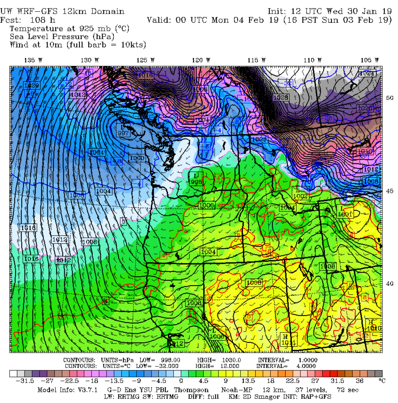
The coldest air of the season is projected to lurch toward the U.S.-Canada border over the weekend, slipping into the northern reaches of our state via the Fraser River Valley on Sunday morning. By afternoon—game time for football fans—brisk northerly winds will send arctic air surging down the I-5 corridor, setting up a potential collision with damper marine air wiggling up from the south.
If forecast models have the right idea, wherever this confrontation occurs could be a real game-changer—for the landscape.
Snow odds: Highest north of Everett
Several inches of snow may fall in a convergence zone of sorts Sunday afternoon into Sunday night as competing air masses duke it out, with the most likely spots for accumulation along and east of a Bellingham-to-Arlington line. Temperatures, which will start out in the upper 30s or low 40s for most of Western Washington, will tumble to near freezing north of Snohomish County by late afternoon as winter strengthens its grip on the state.
Seattle metro: Olympic snow shadow likely to limit accumulations
For the greater Seattle-Everett-Tacoma metro area (from roughly Arlington southward), the frigid weather is likely to hold off until after the Super Bowl, with the University of Washington’s WRF weather model predicting sub-freezing temperatures arriving around midnight. As for Puget Sound snow chances?
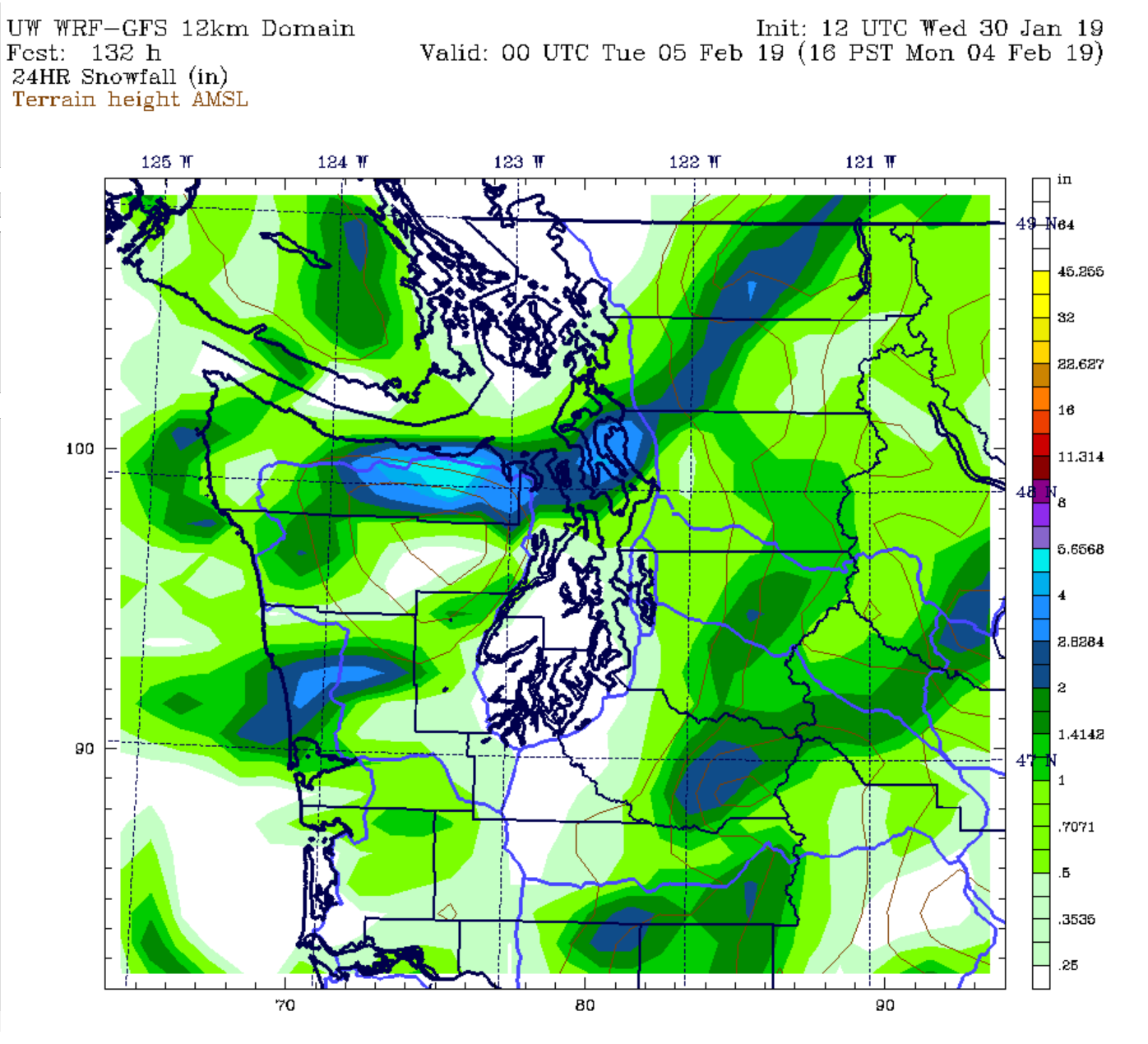
That’s where things get tricky. The latest models indicate that for most of the metro area, snowfall will be sparse—with accumulations of up to an inch possible early Monday morning, mainly from Shoreline north and east. Although it’s too early to lay bets on how Seattle proper will fare, current models suggest the heart of the city is at risk of being snow-shadowed—in other words, blocked from snow by the Olympic Mountains due to an unfavorable (or favorable, if you hail from a warmer clime) wind direction.
Very cold with additional snow chances next week
Unlike many Western Washington snowfalls, the Sunday-Monday event doesn’t look like a classic one-and-done. Rather, forecast models are increasingly pointing to multiple snow chances next week—at this time, Wednesday and Thursday seem to have the highest odds. Why? Because confidence is increasing that the cold air ushered in Sunday night will be around for the relative long haul—in Seattle-speak, a solid five days or so.
What seems most certain at this point is that, regardless of how much snow falls, Monday and Tuesday will likely wind up as the coldest days this winter (and our coldest days since last February). Highs will plunge from the low 40s on Sunday to the low 30s on Monday—with Seattle potentially not cracking the freezing mark for the first time in nearly five years (since a high of 29 degrees on Feb. 6, 2014). Skies will likely turn sunny by midday as a dry arctic airmass settles in, but the frigid temperatures will keep most of Pugetopolis indoors.
Tuesday should feature ample sunshine and temperatures a smidge warmer—perhaps topping out in the mid-30s in Seattle, with a few more degrees of warming into Wednesday before the next snow threat unfolds.
Stay tuned as our wintry forecast comes more into focus. And make sure to follow us on Twitter for frequent updates.


