It’s a forecast that should spark a flurry of interest in Seattle.
Literally.
Light snow showers are possible tomorrow afternoon and evening as warmer air from the Pacific clashes with cold air at the surface, triggering a round of flurries throughout the metro area—with some freezing drizzle thrown in for good measure.
In the interim, after another chilly but sunny day, skies will remain clear overnight, allowing temperatures to once again plunge into the lower 20s. For the record, Seattle has sunk below the freezing mark every morning since last Tuesday—with yesterday’s low of 19 degrees the coldest for the city in nearly three years.
A band of clouds spreads in from the north by mid-morning tomorrow, wiping away our sunny start. With gray skies in place, the mercury will be slow to rise, not inching past the freezing mark until early in the afternoon.

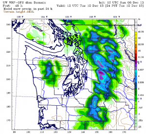
It’s during this time that spotty moisture begins moving into the region, with the best chance of precipitation from Everett north to Bellingham, where the Olympic rain—er, snow—shadow won’t be a factor. Roughly an inch of the white stuff is possible there, with higher totals east of I-5 toward the foothills.
Further south in the Seattle-Tacoma area, the Olympic Mountains should block a good chuck of the incoming moisture from reaching us—leading to just occasional snow flurries at times. Freezing drizzle is also possible as the air mass over Western Washington continues to warm—in this scenario, light rain drops falling from the sky would freeze as they come into contact with the cold ground. Importantly, there should be very little ice accumulation, thanks to the low precipitation amounts we’re expecting (tomorrow will not be a repeat of the Jan. 19, 2012 ice storm—there’s just not enough moisture).
Any snowfall accumulation on Monday is also likely to be negligible, especially from downtown Seattle south through Tacoma, where the flurries probably won’t amount to more than a dusting. North and east of the city, a half-inch or so is possible, with the greatest shot for meaningful accumulation remaining from Snohomish County northward.
Temperatures gradually warm as the night progresses, with any lingering flurries turning over to plain old rain early Tuesday as the mercury creeps into the upper 30s. The one exception to this will be the Everett area, where heavier showers could keep the cold air around longer—leading to another inch of snow.
Everyone switches over to solid rain by Tuesday night, with temperatures holding steady around 40 degrees. Amounts will continue to run on the small side, with 0.10 inches or less for most of the Sound.
We dry out in time for Wednesday, with highs reaching into the mid 40s—the warmest temperatures since the first of the month. A juicy system then rolls through on Thursday, dumping a half-inch of rain on Seattle as more typical late-fall weather resumes.
Just don’t expect a tizzy of excitement to accompany it.


