
All bragging rights with today’s windstorm go to the South Sound.
A strong 977-millibar low roared ashore on the north Washington coast early this morning, plowing east from Forks to Whidbey Island before curving northeast into the North Cascades. The track of the low, which was further south than the Vancouver Island landfall suggested by Saturday’s weather models, brought the strongest winds in the interior from just south of Seattle to Tacoma.
The storm was punctuated by a peak wind gust of 59 mph at Sea-Tac Airport, with a gust to 44 mph in Renton, to the east. Further south, Tacoma saw winds reach 46 mph, while Boeing Field hit 41 and the University of Washington gusted to 45. As expected, winds were even higher on the coast, with Hoquiam reaching 60 mph, and Westport coming in a notch windier at 62.
Meanwhile, from the North Sound up to the Canadian border, speeds were much tamer, due to the center of the low tracking nearly overhead. Everett, for example, only recorded a peak gust of 28 mph, while Mount Vernon topped out at 31. Bellingham, however, one-upped both places for wind futility, registering a maximum gust of just 23 mph last night—a barely noticeable speed for the usually wind-prone city.
Fortunately, for North Sounders feeling slighted by this morning’s storm, redemption is on the way—in the form of snow.
Colder air is already funneling into Western Washington behind the low, with noontime temperatures sitting in the low to mid 40s—several degrees cooler than the upper 40s seen this morning at the height of the storm. As the day progresses, the mercury will continue to plummet, falling into the upper 30s by sunset. At the same time, a Puget Sound Convergence Zone is expected to set up shop anywhere from Everett to Bellingham, dropping the snow level to near sea level as heavier showers move through.
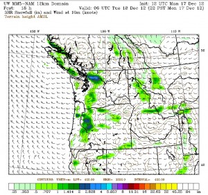
As of noon today, models indicate that the Convergence Zone will form further north than usual, most likely from north Snohomish County into Skagit County. The University of Washington’s NAM model, which correctly predicted the track of this morning’s windstorm, paints a band of moderate to heavy snowfall along I-5 from Stanwood to Mount Vernon and points east later tonight. Snow should begin in these areas after 7 p.m., and continue for a few hours, weakening around midnight as the Zone shifts into the Cascades.
Further south in the Seattle/Everett area, light snow—from a dusting to an inch—is also possible overnight, with the best chances for snow in the higher hills east of Everett and Lake Washington. For Seattle proper, no accumulating snow is anticipated—but nighttime showers could bring a rain/snow mix to higher elevations in the city, including the Queen Anne, Capitol Hill and Maple Leaf neighborhoods.
Temperatures will gradually rise into the upper 30s later tomorrow morning, melting off any snow that does fall—but it’ll be a cold day regardless, with highs struggling to reach 40 degrees. Some clearing is possible later in the day and at night, before another front swings through the region Wednesday morning. Because of the cold air in place, precipitation with this system could begin as snow in the metro area—including Seattle—early in the day, before changing to rain as warmer winds from the south take hold.
Until then, it’ll be a wild 48 hours across Western Washington—especially in the North Sound, which looks to reclaim bragging rights from the South Sound starting tonight.


Hi Justin. I just found this blog this morning; thank you! I was wondering if you could keep a table somewhere on the website with maybe monthly rainfall MTD, and YTD? That would be awesome. Thanks again!
Hi Erik,
Thanks for checking out the site–and that’s a great suggestion! I’ll definitely look into putting something up on the site that’s easy to check on a frequent basis, as that information would be pretty handy.
Great, thanks! I used to check out another website (http://www.beautifulseattle.com) that is no longer active. They had monthly tables on their site with daily high and low temps, rain/snow fall amounts, peak wind-speed and daily record highs and lows. That would be a lot of work, but the tables were awesome! No pressure… 🙂 Thank again, I will be checking back regularly.
Erik
Yeah, that would be too crazy of an undertaking for me–but fortunately, you can find all that stuff on the Seattle National Weather Service’s website as well. Check out this link, it’s pretty sweet! (Since it snowed at Sea-Tac today, they’ll also be adding a snowfall column to the December chart pretty soon.) http://www.wrh.noaa.gov/climate/monthdisp.php?stn=KSEA&year=2012&mon=12&wfo=sew&p=temperature
Great, that site looks awesome. Thanks for the link!