
After several days of widely varying scenarios concerning Wednesday’s storm, forecast models have finally arrived at a general consensus regarding snowfall totals for Wednesday’s upcoming storm. Their prediction? Anywhere from 8 to 12 inches of heavy, wet snow–in other words, the definition of an epic snowstorm for Seattle.
The fun will begin shortly after midnight Wednesday morning, as a surface area of low pressure makes landfall around Astoria and heads northeast. As it does, cold air bottled up in British Columbia will flood southward into Western Washington, drawn toward the low like bees to honey. Simultaneously, moisture from the low’s associated front will stream northward, resulting in a collision between warm and cold that will make Wednesday the snowiest day in the Seattle area since Dec. 29, 1996.
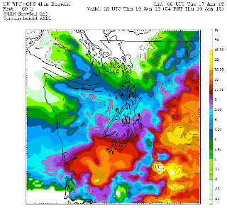 |
| The UW’s WRF model is forecasting 8″ of snow for much of Seattle by 4 p.m. Wednesday |
8-plus inches fell on downtown Seattle that day (unfortunately, Sea-Tac Airport had stopped recording daily snowfall earlier in the year), an amount that will likely be matched, and possibly exceeded, by Wednesday evening.
The University of Washington’s WRF-GFS model is predicting eight inches of snow by Wednesday at 4 p.m. for the area between Downtown Seattle and SeaTac Airport and points east. Amounts in the metro area north of this line will range from 6 to 8 inches, tapering off to 4 inches around Everett. Further south, around Tacoma, snow amounts will close in on 10 inches, with a foot of snow possible for Olympia.
Keep in mind, however, that these amounts are by no means final. Any deviation in the track of Wednesday morning’s low pressure system will shift the heaviest snow to the north or south (if the low tracks further north than Astoria, areas from Seattle to Everett will see the heaviest snow, if the low tracks south of Astoria, areas from Olympia south will see the most snow).
The snow should begin to taper off Wednesday night, mixing with rain as the storm winds down. Note that this is a significant change from previous forecasts, which had the snow transitioning to rain by early afternoon. Today’s models have backed off on that notion, meaning that most of the precipitation that falls Wednesday will be snow–that of the 31 to 34 degrees variety. Talk about a snowy, slushy mess.
Lastly, note that prior to Wednesday’s snowstorm of the century (hey, the decade’s only two years old), there is still a chance for some snow showers later tonight into tomorrow morning. At this point, accumulations look nil for the metro area, due to an increase in southerly winds that’s already bumped temperatures up to their warmest readings of the day. (To wit, Boeing Field was 35 degrees at 10 o’clock.)
Rest assured, there’s no need to worry over the lack of snow tonight–Wednesday will make up for things tenfold.
And then some.


Let's break some records!