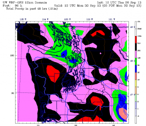
This month is fast becoming a September to remember.
First, there were the strong thunderstorms that inundated Seattle with over a month’s worth of rain in 24 hours. Then, there was the intense late summer-heat that ratcheted the mercury up to 93 degrees on Sept. 11—our third-warmest September day ever. And now, in the final stretch, comes this parting shot: a powerful frontal system bent on pummeling the region with 2 inches of heavy rain—enough to make this one of Seattle’s wettest Septembers on record.
And you thought November was when the real action got started.
We’re leapfrogging right into the heart of wild fall weather this weekend as a wet, windy storm bears down on us from the Pacific. For the Seattle area, Saturday is likely to be a washout, with a soaking rain in the cards early in the morning, and then again from the evening hours onward. First, though, we’ve got a weaker front on deck to whet our appetite—just in time for Friday.

After a partly sunny and pleasant fall afternoon, skies will cloud up in earnest later tonight as a cold front zips toward us from the northwest. By Friday morning, light rain should be falling across the entire metro area, with temperatures holding steady in the low to mid 50s.
The front clears out of here late tomorrow afternoon after dropping relatively minuscule amounts of rain across the Sound—most places will collect less than a quarter-inch. The clouds, however, won’t be leaving anytime soon, allowing temperatures to stall out in the upper 50s for highs—far short of the typical upper 60s we see this time of year.
The bottom falls out on Saturday as heavy rain creeps into the area from the south during the morning, dries up around noon, then returns with a vengeance at nighttime as a powerful cold front slams ashore. As the front nears, winds will also pick up across the area, gusting up to 40 mph late Saturday. By early Sunday, the winds should die down, but rain will continue at times, albeit at a more moderate pace.
All told, rainfall amounts from Saturday through Sunday are likely to be pretty substantial, with the latest forecast models painting a broad swath of 1.5 to 2 inches of moisture from roughly Seattle northward, with the potential for even more south and east of the city. With 3.03 inches of rain already on the books this September, another 2 inches would place the month third on the list of all-time wettest Septembers—5.95 inches fell in September 1978, and 5.57 inches swamped the city in 1969. (4.80 inches fell just three years ago in 2010.)
We slowly dry out as Sunday bleeds into Monday, with showers at the start of the workweek totaling just a quarter-inch—a respectable amount for most September days, but likely nothing more than a drop in the bucket after this weekend’s anticipated deluge.
Talk about a September to remember—or forget.


What does this mean for the rest of the fall and winter season, could this be our only big event.
Hi Mike,
Good question. Because it’s officially a “neutral” fall/winter—in other words, there’s no El Nino or La Nina brewing in the Pacific—I’d bet that we’re due for a similar rainmaker or two come November or December. In terms of winds, it’s almost a lock that we’ll see higher speeds later in the fall. But it’s probably a safe bet to say that we won’t see a system like this in a future September for quite some time.