
The break is over.
Rain is spreading back into the region today after an eight-day absence—the city’s longest stretch without the wet stuff since August. Although it’s been more clouds than sun in Seattle recently, up until now we’ve been spared any rainfall since strong thunderstorms rocked the Sound overnight Sept. 5-6.
Speaking of thunder…
Bands of thunder, lightning and rain have already barged into the region this morning, thanks to an area of low pressure racing up the Oregon coast. This low is pulling moist, unstable air up from the southeast—which in turn is allowing thunderstorms forming over the Cascades to drift into our neck of the woods on a northwest path.
So far, most of the activity has been confined to the South Sound, where residents were jolted awake this morning by a line of thunderstorms zipping through around 9 a.m. These storms have since moved off into the Olympic Peninsula, where they continue to march west.
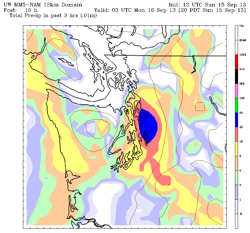
As we head into the afternoon hours, additional storms are expected to wander in from the mountains, complete with occasional rumbles of thunder and flashes of lightning. Heavy rain and periodic downpours will also be possible, with up to a half an inch of rain falling in some spots—especially east of I-5. As super-charged as the atmosphere surrounding the Seahawks-49ers game is, it could become downright electrifying by kickoff should any of these storms move in overhead.
Things calm later tonight as low pressure shifts north, leaving us with just scattered showers. With cloudy skies throughout, the mercury will barely budge from its mid-60s high—allowing Seattle to easily secure its 40th consecutive above-average low temperature.
Showers continue to dot the region through tomorrow afternoon, eventually winding down in the early evening. Temperatures will again hover in the mid 60s most of the day as gray skies envelop the region.
After a brief break early Tuesday, light rain returns during the second part of the day, with a quarter-inch possible through early Wednesday. We then dry out in time for Thursday as high pressure nudges in, sending temperatures back into the 70s with plenty of sun.
Until then, it’s the rain’s turn to shine.


