
While you were sleeping, the rain came back.
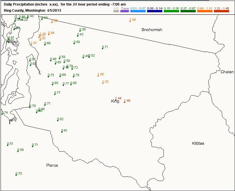
After tapering off in the early evening yesterday, another batch of moisture rolled through Seattle overnight, dousing the city once more. The early morning soaking boosted 24-hour rainfalls totals to the one-inch mark in some parts of the city—especially north of the Ship Canal—while officially giving Sea-Tac Airport 0.73 inches of precipitation since yesterday morning.
As if that wasn’t enough, more soggy weather is on the way.
First up, though, is our current well-deserved break from the action, which will last through this afternoon as westerly winds above the surface move the Olympic rain shadow over the area. With cloudy skies prevailing, temperatures will max out in the mid 50s—normal for this time of year. (On an interesting side note, Thursday’s high of 58—one degree above average—extended Seattle’s streak of warmer-than-normal days to 11.)
The respite ends quickly tonight as a deep area of low pressure barrels north of Vancouver Island, dragging a potent cold front southward through Puget Sound. Rain should spread back into the region by 9 p.m. tonight, continuing at a moderate clip through early Saturday morning. Expect amounts of up to half an inch, with the bulk again falling while you’re dozing.
Most areas should dry out by late tomorrow morning, with partly sunny skies setting in around lunchtime. However, with the increasing sunshine will come another threat—thunderstorms. With a cold air mass overhead, warmer air at the surface—heated by the sun—will be able to rise rather quickly (since warm air is lighter than cold air). As the warm, moist air rises, it’ll cool and condense, leading to clouds, showers and even thunderstorms.
Right now, the best chance for thunder and lightning looks to be east of 405, closer to the foothills. The European weather model in particular paints some rather hefty storms over the Issaquah/North Bend area late tomorrow afternoon, with Seattle proper staying mainly dry. In any case, whatever showers or thunderstorms do form will come to an end by Saturday evening.
But wait, there’s more. A third and final system will plow onshore near Astoria overnight Saturday into Sunday, drenching the Seattle area with another bout of rain as its tracks northeast. (Earlier in the week, this system was forecast to come in much further south, leaving us high and dry.) By the waking hours of Sunday morning—sorry Seattle, but you can’t sleep your way through this one—steady rains are likely across all of Puget Sound. Rainfall totals will likely close in on 0.75 inches, with some places south and east of Seattle logging up to an inch.
The rain changes to showers by Sunday afternoon, with precipitation winding down from west to east as we head into the evening. Some sunshine is even possible by then, but it’ll do little to warm things up—with a cold air mass lingering overhead, high temperatures on Sunday will struggle to reach the mid 50s. Drier weather then returns Monday into Tuesday, before another rainmaker approaches late Tuesday night.
Fortunately, you should be in a deep slumber by then.


