
We’ve already earned a share of the bronze, and by Friday, we could be gunning for silver.
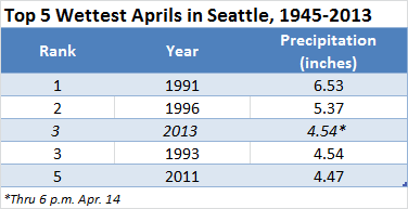
In the wake of a spectacular hailstorm that blasted through Seattle yesterday afternoon, overnight rains pushed this month’s precipitation total to 4.54 inches, making April 2013 the third-wettest April (tied with 1993) on record at Sea-Tac Airport. The stormy weather, which dropped nearly an inch of rain on the city from Friday through this morning, has since moved on—but with another rainmaker on the horizon, we could threaten April 1996 for the number two spot later this week.
First up, though, is a well-earned reprieve.
Our break from the wild weather is already underway across most of Puget Sound, with the bulk of today’s showers staying south of the metro area. As we head further into the evening, we’ll see these pop-up cells drift even further south, thanks to northerly winds in the upper levels of the atmosphere.
With a cold area of low pressure still parked overhead, temperatures tonight should bottom out in the upper 30s—on par with the 38-degree reading observed yesterday morning (Seattle’s coldest temperature so far this April). Abundant spring sunshine, however, will warm us back in the mid 50s by Monday afternoon. A few scattered showers are also possible later in the day, but they should stay south and east of the city.
The calm weather continues into Tuesday, with mostly sunny skies and temperatures surging back into the upper 50s—the norm for the second week of April. Wednesday should also be rain-free, although an uptick in clouds during the afternoon will signal the approach of our latest spring soaker.
Thursday starts off dry, but by the afternoon, steady rains can be expected across the entire area as a cold front punches through. The worst of the moisture will likely fall late Thursday night into early Friday, dropping around half an inch of rain in Seattle. This would nudge April’s rainfall tally past the 5-inch mark—within striking distance of the 5.37 inches recorded at the airport in April 1996. (First place on the list of Seattle’s wettest Aprils belongs to 1991, with 6.53 inches.)
Additional showers are likely later Friday, especially in a Puget Sound Convergence Zone, before the precipitation wraps in time for the weekend. At this point, next Saturday looks dry.
No doubt welcome news for rain-weary Seattleites exhausted by all this medal-chasing.


Was 1991 6.93 or 6.53″? You list both numbers.
It was 6.53″–thanks for pointing that out. It’s now been fixed.
Wettest Aprils ever all since 1991. Can I get some other decades please? GHGs baby
Ok seattle time to build that ark! But when you see gods face as he pokes in for a look, SOCK HIM IN THE EYE!!!! I was born here, after 50 years of this, it begins wears on you…. The N.W. looks great in the Sun, but this is how we pay for it, it stinks I know but…