So that’s what 2-plus inches of rain feels like.
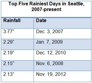
Sea-Tac Airport measured a whopping 2.13 inches of precipitation yesterday, giving Seattle its first 2-inch daily rainfall in almost two years. While in recent times we’ve typically seen one 2-inch rain day a year (it’s happened on 10 occasions since 2000), that wasn’t the case in 2011. Last year’s wettest day constituted “only” 1.76 inches—handing Seattle its first year without a 2-inch rainfall since 2004, and making yesterday’s drenching all the more memorable. (Our last 2-inch-plus day came on Dec. 12, 2010, with 2.19 inches.)
The 2.13 inches of rain easily broke the mark for the soggiest Nov. 19 at Sea-Tac, besting the 1962 record by .90 inches. At the National Weather Service office in Sandpoint, it was even wetter—with the 2.60 inches that fell Monday more than doubling the previous record of 1.16 inches for the day, set there in 2003. (Rainfall measurements have been taken at the Sandpoint office since 1986.)

In the wake of yesterday’s heavy rainfall, today will be much drier, with the worst of the rain—a late-morning dousing of .14 inches—already behind us. (The midday rain was enough to bump Seattle’s November precipitation up to exactly 5 inches, as of 1 p.m.) However, fairly windy conditions are still possible around the Sound through 6 p.m., with gusts up to 45 mph. Temperatures will remain steady in the mid 40s.
Another cold front will bring a burst of rain early tomorrow, with a third of an inch of rain falling in Seattle by mid-morning. (A truly menial amount when compared to the one inch already in the bucket by 9 a.m. yesterday.) Behind the front, strong breezes will kick up again, and we’ll see more gusts from 30-40 mph.
The rain tapers off later tomorrow afternoon, setting the stage for an umbrella-free Thanksgiving. Thursday looks dry from just about start to finish, with only a few scattered showers over the Olympic Peninsula and in the mountains early in the day. Highs will again rise to about 50 degrees—the average for this time of year.
Lo and behold, another wet, blustery system arrives on Friday, dropping up to half an inch of rain around the metro area. Beyond that, however, the weather looks remarkably dry for several days as a high pressure ridge forms over the eastern Pacific. Partly sunny skies and cooler temperatures (think lower to mid 40s)—are a good bet on Saturday and again the following day—great news for the 2,000-plus people expected to run in the Seattle Marathon on Sunday.
And for the rest of rain-weary Seattle, still drying out from the most waterlogged day since late fall 2010.


I’ve been looking everywhere for the record for most precipitation in a year in Seattle. I’ve found every record…except this one. Just interested as we’re on track currently to finish the year 10+ inches above average.
Hi James,
Great question–the record for most precipitation in a year is 55.14 inches, set in 1950. Just shows how wet that year truly was–as we’re still 8 inches behind 1950, despite recording almost 10 inches more precipitation than normal!
Thanks! I’ve looked everywhere for this stat. Happy Wet Christmas!