Our first heavy rain event of the season has officially brought 1.56″ of rain (and counting!) to Seattle today–the most recorded since last Dec. 12, when 2.19″ of rain was measured.
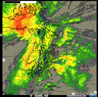
Rainfall has diminished slightly since the downpours of mid-afternoon, as the heaviest precipitation has shifted north to the Everett area. Current model forecasts shift this heavy rain band back south through the metro area during the overnight hours, primarily between 1 and 4 a.m. (good news for those of you not wanting to drive to work in the pounding rain for the third straight morning).
 |
| Weather Underground image showing the heaviest precipitation to the north and west of Seattle Tuesday night |
Rainfall will quickly taper off tomorrow morning, with the area largely moisture-free by the lunch hour. For the rest of Wednesday, scattered showers and cloudy skies will be the rule of thumb, although it is possible we could even see a patch of clear sky here and there. Just don’t hold your breath. Highs will top out in the upper 40s–just a hair or two less than normal for this time of year.
Alas, the break from the rain will be short lived, as another strong front is poised to move through the region during the afternoon on Thanksgiving Day. This storm, while still packing quite the punch in regards to wind and rain, will move through the area much quicker, meaning that the steady rains will be limited to six hours or so, versus 24.
Is that improvement, or what?


