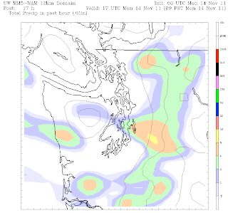
If you found yourself getting a little tired of the gray skies this weekend, Monday won’t be the best day for you–more clouds are in order, along with occasional showers, especially for the morning commute.
A healthy dose of moisture should move through overnight, and then on-and-off showers will persist around the Seattle area through tomorrow morning. The afternoon does promise to eke out a couple more sunbreaks, as long as you don’t live north of Seattle, where the Puget Sound Convergence Zone will keep things wet. The Zone is likely to sag south as the day continues, leading to a chance of rain again over much of the metro area tomorrow night.
 |
| NAM computer model showing rain moving through Puget Sound Monday morning |
Come Tuesday, the rain will be winding down, and at this point, the afternoon actually looks decently sunny. The only downside? The lack of warmth. While temperatures on Monday will hover around the upper 40s, by Tuesday, highs will struggle to reach the mid- to-lower 40s, as freezing temperatures in the morning will prevent us from topping Monday’s highs.
The rain and wind return again for Wednesday as a more vigorous system takes aim at the region from the west. Amid blustery winds (possibly exceeding 40 mph in some of the wind-prone areas around the region), temperatures will surge into the lower 50s, before crashing back in the mid- to-low 40s by the weekend.
Friday through Sunday continues to look rather cold by mid-November standards, with overnight lows coming close to the freezing mark. At this point, a widespread lowland snow event looks unlikely, but some of you in outlying areas like Issaquah and North Bend, as well as folks in the Convergence Zone up around Everett, could definitely see some wet snow at times in the late night and early morning hours on Saturday and Sunday.
Stay tuned.


