
The office may be closed this weekend, but there’s one familiar friend that will be opening up shop Friday night.
That’s right, the rain is back in business—just in time for your days off.
A classic fall storm is set to take aim at Seattle this weekend, bringing an end to our extended stretch of dry, inactive weather. To wit, we haven’t seen anything more than dribs and drabs of moisture since 0.36 fell on the 11th of the month—before fog swept in and shrouded the city in gray for days on end. Now, with the fog long gone and our brief sunny spell in the books, it’s time for the rain to once again make itself known in the Northwest.
Rest assured, it won’t take very long.
A strong frontal system over the eastern Pacific will lumber toward the region tomorrow, thickening the cloudcover and ultimately spreading rain back into the state by nightfall Friday. Fortunately, most of us will stay dry up until then, with just a smattering of showers north of Seattle during the prime trick-or-treat hours tonight. (With no more moisture expected in the city itself through today, October will wrap up with barely an inch and a half of rain to its name—nearly 2 inches under the norm of 3.48.)
With cloudy skies stuck in place, temperatures overnight into Friday will stay on the warm side, only dropping into the upper 40s. We’ll then rise back into the mid 50s during the day tomorrow—roughly on par with the average high for early November.
The rain arrives shortly after the evening commute Friday, and for a city that went all of October without a good-old fashioned drenching, it’ll be noticeable. Moderate to occasionally heavy rain is likely just about everywhere late Friday into early Saturday, with most areas picking up a solid half-inch.
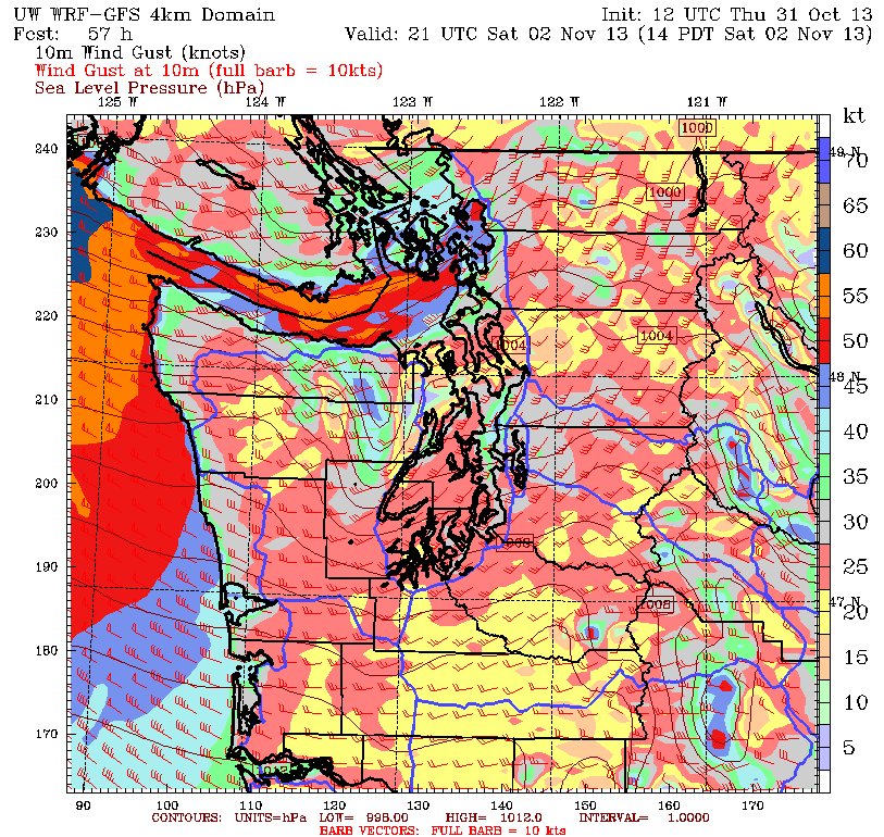
Showers taper off by noon on Saturday, but there’s a trade-off: increasing wind. With the area of low pressure tied to this storm expected to veer across southern B.C., winds will really pick up out of the south by mid-morning, gusting to 35 mph across the greater Seattle area. Further north, it’ll be even more blustery, as strong winds accelerate down the Strait of Juan de Fuca, potentially lashing the western shore of Whidbey Island with 60-mph gusts.
The winds slowly relax Saturday evening, and by Sunday morning, we should be calm region-wide. Some sunbreaks are even likely during the afternoon hours. However, we’ll cool off substantially in the wake of the storm, with afternoon highs struggling to reach 50 degrees. Things then stay dry into Monday, before the next rainmaker sails ashore on Tuesday—with another shot of rain expected Wednesday.
In other words, it’s back to business as usual for a while.


