Here’s to 40 and beyond.
Moderate rain showers hit Sea-Tac Airport earlier this afternoon, lifting the total precipitation observed in Seattle this year above 40 inches—some 2.5 inches higher than the yearly norm, with a month and a day to go. With the rainy pattern that began yesterday expected to remain in place well into next week, we’ll continue to pad our 2012 rainfall stats as the calendar turns to December, possibly reaching 42 inches by the end of next week.
However, as impressively soggy as the year has been—despite the fact that we saw the driest two-and-a-half-month period in Seattle history earlier this year—it’ll take a fairly wet December for 2012 to one-up the 46.99 inches that fell just two years ago.
Then again, 2010 wasn’t exactly waterlogged until December came calling. At the close of a wild November—highlighted by a record-setting 2.5 inches of snow on Nov. 22, 2010 and three straight days of temperatures at or below freezing—total precipitation at Sea-Tac stood at 38.30 inches. Very wet conditions, however, took hold during the second week of December—we saw 3.61 inches from Dec. 12-13, 2010 alone—propelling Seattle to its seventh-wettest December on record, with 8.69 inches (our average December rainfall is 5.35 inches).

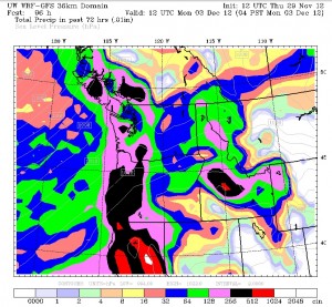
While this December looks to get off to a wet start—it should rain on-and-off Saturday through Monday—there’s no sign of a big soaker in the near future. Rather, the Seattle area will see anywhere from a quarter to half an inch of rain for the first few days of the month—as well as a similar amount for tomorrow, November’s final day—as we remain on the north end of a powerful jet stream driving storms into Northern California. (Extremely heavy rains are predicted down there through Sunday, with up to 18 inches of rain possible near Mount Shasta this weekend.)
High temperatures tomorrow and through the weekend will generally run in the upper 40s to lower 50s around the Sound—slightly warmer than average for the most part. With cloudy skies throughout, overnight lows will also stay on the balmy side—in the low to mid 40s. Breezy conditions are also possible at times, especially north and west of Everett.
The storm track shifts further north early next week, drying out the Golden State, but continuing the rain in Seattle as our yearly rainfall total creeps upward from 40 inches.
Fortunately, it doesn’t look like we’ll be topping the 2010 mark anytime soon.


