
Sure, we’ve been dealing with some snow over the past 24 hours, but the Seattle area has held up just fine—there really haven’t been too many sticky situations.
Literally.
Occasional snow showers have fallen from the skies over Puget Sound ever since yesterday morning’s cold front blasted through, but with temperatures generally hovering above the freezing mark, little in the way of snow has stuck. In addition, most of the flakes have been limited to places north of the I-90 corridor, where heavier showers in a Puget Sound Convergence Zone have dragged the snow level down near the surface at times.
As we head into the evening hours, any lingering showering activity will come to an end as the Convergence Zone weakens and slips south of the metro area. Skies will also begin to gradually clear from the north, sending our already chilly temperatures tumbling well below the freezing mark. By tomorrow morning, most places should be below 30 degrees—with outlying areas in the South Sound bottoming out in the lower 20s.
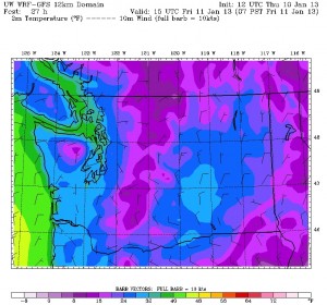
Dry and cold conditions will stay in place the rest of the day, with temperatures barely rising into the mid 30s—some ten degrees below the 47-degree average high for the date. A high below 38 in Seattle would make for our coldest high temperature since Jan. 19 of last year, when an unrelenting ice storm held the mercury at 30 degrees or below the entire day.
We’ll also see some sunshine during the first half of the day, before clouds from a system passing by offshore darken things up a bit in the afternoon. Skies will stay partly cloudy overnight into Saturday, but with more cold air trickling in, temperatures will still manage to drop into the lower 30s.
Another weak front glides by to our west during the afternoon on Saturday, throwing more clouds in our direction—but importantly, little to no moisture. Earlier weather models brought this system in closer to Seattle, which would have meant a chance for some widespread light snow, but that now looks pretty unlikely. It’ll remain cold, however, with the mercury again failing to advance past the mid 30s.
The cold air starts to lose its grip a bit on Sunday, as a strong area of high pressure parked over the Pacific moves closer to the coast, shunting our chilly temperatures eastward. Temperatures will still remain on the minus side of normal—peaking near 40 degrees—but they shouldn’t be quite as cold as tomorrow or Saturday.
Similar conditions are also likely early next week, with sunny skies boosting readings into the lower 40s during the daytime. Nighttime clearing should allow for lows to drop back to the freezing mark both Monday and Tuesday—making for cold, crisp mornings.
Without the threat of anything white.


Thanks for info and insights Justin! Always appreciated.
Thanks–and enjoy the sunshine!