

Perhaps Frozen 2 should have been set in Seattle, circa early 2020?
A blast of frigid air from Canada, cold enough to impress even Elsa and Anna, is on a collision course with Seattle—set to engulf the city late this weekend into early next week. As the leading edge of the bitterly cold air mass dives south from B.C., icy winds will descend on the region from the north, howling upwards of 40 mph in spots late Sunday into Monday morning.
Oh, and snow is possible at times through the end of next week as well.
But before we get to that, let’s rewind to the short-term.
Rain/snow mix in Seattle Thursday, Friday mornings
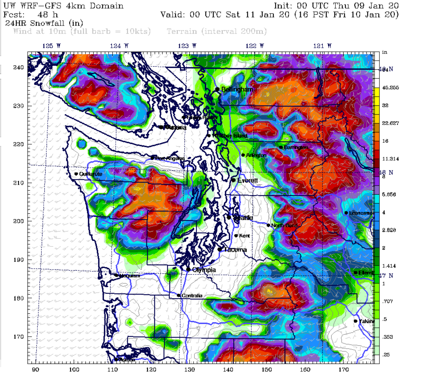
Wet snow or a rain/snow mix is likely both Thursday and Friday mornings, even in Seattle proper, as chilly air clips the region from the northwest. Minor accumulations are possible late at night through mid-morning in places roughly 500 feet or higher—but because road temperatures will be well above freezing, little to no road impacts are expected. Any snow that sticks will likely stick to only rooftops, cartops, dirt and grass—with the best odds from Shoreline northward.
A slightly warmer storm system then looks to cross to our north later Friday, bringing another round of moderate rain and some breezy winds. Showers linger well into Saturday, before another area of low pressure swirls in from the northwest on Sunday, yielding another bout of cool, rainy weather. And then the fun begins.
Arctic air invades Seattle Sunday night
In the wake of Sunday’s storm, frigid air will plunge south from the Canadian interior, spilling into Western Washington via the Fraser River Valley. Temperatures will tumble rapidly as the arctic air barrels south, going from the low 40s Sunday at noon to the upper 20s by the time Monday morning rolls around. An inch (or two) of snow is possible by sunrise Monday as northerly winds whipping down the Sound run smack-dab into warmer winds coming up from the south. School districts, be on guard for potential delays and/or closings Monday morning.
With arctic air settling in, temperatures will barely creep above the freezing mark Monday afternoon, only touching the mid-30s in warmer spots like downtown Seattle. Many suburbs will struggle to top 30 degrees.
Subfreezing high temperatures possible Tuesday & Wednesday
Forecast models predict the frigid air will remain locked in place Tuesday and Wednesday, with high temperatures only reaching the mid-to-upper 20s. For a city where the average mid-January high is 47 degrees, that’s plain bonkers! Note that Seattle typically only records a handful of subfreezing highs each decade. Our last one occurred Feb. 6, 2014—the day after the Seahawks’ championship parade—when the mercury maxed out at just 29 degrees.
Even more impressive, should the temperature fail to climb out of the 20s both Tuesday and Wednesday, it would mark Seattle’s first instance of consecutive highs in the 20s since November 2010. Overnight lows stand to be even worse, likely dipping into the teens both nights.
Bigger snow threat later next week
The cold may moderate a touch later Wednesday into Thursday and Friday, but it could come at a cost. Some forecast models are hinting that a low-pressure system may dive into northern Oregon, spreading moisture up from the south. With cold air in place, snow—possibly several inches’ worth—could easily blanket Seattle, potentially bringing the city to a halt later next week.
But that’s another blog post for another time. For now, it’s time to seriously prepare for some wicked cold, as well as some light snowfall.
We’ll continue to provide more information as the situation evolves. Follow us on Twitter for real-time updates.


[…] that, a front of cold air is set to move through the region beginning Sunday. According to Seattle Weather Blog’s Justin Shaw, that will send temperatures tumbling from the low 40s early Sunday afternoon, all the way down to […]
[…] winds whipping down the Sound run smack-dab into warmer winds coming up from the south,” the Seattle Weather Blog warns. “School districts, be on guard for potential delays and/or closings Monday […]