
Local ice scrapers must be getting pretty bored.
Temperatures haven’t reached the freezing mark in Seattle since Nov. 10, when the mercury dropped to 31 degrees under crisp, clear skies. Since then, it’s been a month-long stretch of frost-free nights across the metro area, with overnight low temperatures generally running a few degrees above average. This has been especially true recently, as evidenced by readings taken at Sea-Tac Airport, where an average low hasn’t been recorded since Nov. 28. (Normal lows, from then until now, have ranged from 35 to 37 degrees.)
The toastier-than-usual a.m. temperatures have resulted from a string of overcast nights—with persistent cloud cover blocking the day’s heat from escaping to space. On the flip side, the extensive cloudiness has kept our high temperatures from straying too far from normal—every day in the past week has seen a high within 2 degrees of average.
We’ll stay the course through the coming weekend, with continued clouds keeping our ice scrapers idle. Area windshield wipers, however, will be back on the clock as a new parade of storms marches through. The first in the series, due in tonight, will be relatively weak, spreading .20 to .30 inches around the Sound. Rain should begin by 9 p.m., falling primarily through the night, before wrapping up around the morning commute.
The second storm arrives Saturday morning, dumping up to half an inch of rain over Seattle and kicking up the winds north of Everett and along the Olympic Peninsula. Although this storm looks decently wet for Seattle—we haven’t seen .50 inches of rain since Dec. 4—it’s possible that it could end up somewhat drier, as weather models of late have been over-estimating rainfall totals.
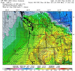
A break in the action comes Saturday night and Sunday, with rain changing to scattered showers, before the third storm—a strong area of low pressure—nears the coast Sunday night or Monday. Accompanied by another slug of moisture, this low has the potential to rake the Puget Sound region with the strongest winds of the season—but only if it makes landfall near southern Vancouver Island (as this morning’s weather model from the University of Washington suggests). If the low heads inland further north—say, over central or northern Vancouver Island, which other models predict—gusty winds will be limited to the usual places like Bellingham and the coast. In either case, wind speeds with the low likely won’t be enough to cause a bona fide windstorm—peak gusts should stay below 50 mph.
Quieter weather resumes in the wake of the Sunday night/Monday storm, with showers and cooler temperatures in the forecast for next Tuesday. In fact, a shot of colder air streaming in later in the day could drag overnight lows back into the mid 30s—or even down to freezing if it gets just a little chillier.
Which would mean employment at last for the multitude of down-on-their-luck ice scrapers in Puget Sound.


